Through Reddit, I found an interesting post from the Preservation Research Office website about the history of the River Des Peres: The Harnessed Channel: How the River Des Peres Became a Sewer.
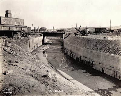
Along the southwest edge of the city of St. Louis, Missouri runs a six-mile curve of what appears to be a river with paved banks. This river is usually dry and rarely filled to even half its capacity. Covered in rip-rap and white stones along this six miles, the banks form a visual boundary of the city limits — although the actual city line is several hundred yards west. Still, the moat-like river creates an effective border between the middle-class parts of the county and city that occupy either side of it. Yet this river actually unites them, because it carries away all of their wasted water and, deep below its channel, their sewage. The river is the River Des Peres, a harnessed channel that was transformed from a natural waterway into a massive civil engineering project in the early twentieth century.
I always knew the 'river' wasn't much of a natural resource anymore—most of the visible length of it is paved in concrete and full of riprap—but I didn't know there's a huge sewer canal under the visible channel! Definitely worth a read, especially if you live near this interesting man-made St. Louis sewage backbone.